Quick update

Well it’s been over a year since I last posted here … and I’ll admit that is out of pure laziness. Sorry about that. I’ll try to find some time, but now that I’m in graduate school I’ve been rather busy.

Over the past year I’ve found numerous species of ants and experienced some interesting weather. I’ve since relocated to North Dakota, which has a notably colder and drier climate than New Jersey. While out here, I’ve experienced temperatures as low as -32 degrees (F)! Another amazing phenomena I couldn’t see back in New Jersey is the northern lights. These are simply amazing. It’s hard to find the words to describe how majestic and awe-inspiring they are, so, I’ll just post a few pictures:

(I tried uploading pictures but they never uploaded … I’ll try again soon)

I’ve also been on a few ant-hunting trips in the past year, each time seeing species that are new to me. Most recently, I saw Dolichoderus plagiatus … a rather colorful ant that I have not seen until this year.  I’ll post a few pictures of these below (pictures wouldn’t upload properly).

Another ant has been a focus of my attention lately. This species, Anergates atratulus, is quite rare. This ant is a worker-less obligate parasite of Tetramorium caespitum (sp. E). I manage to find these rather frequently in my swimming pool back in New Jersey. I made a little experiment which I will describe in more detail in a separate post. Overall, a fascinating species and I managed to get some cool video of them.

Since it’s been a year, there’s obviously more I will need to mention. But for now, I’ll take it easy and start slow. Thanks for being patient, and I’ll try my best to post more often!

Thanks for reading!

Posted in Uncategorized | Leave a comment

Camponotus nuptial flights.

The month of March went down as one of the warmest months ever, for North America that is. The rest of the Earth was actually slightly cooler than normal.

A few days ago, central NJ hit 80 and then 90 degrees. Very impressive warmth for mid-April, but not unprecedented. The warmth led to the nuptial flights of at least three Camponotus species. These include C. caryae, C. pennsylvanicus, and C. chromaiodes. I took some pictures and even recorded a video.

The video can be seen here:

http://www.youtube.com/watch?v=JIsG3oBq89I&feature=g-all-lik&context=G214404aFAAAAAAAAHAA

Also, here are some of the pictures I mentioned that came out pretty well.

These are what people typically refer to as carpenter ants. They inhabit rotting wood and and can be a significant pest if they decide to nest in a structure or home. Many are typically nocturnal but C. caryae is day-active.

Posted in Uncategorized | 4 Comments

A quick look at the weather.

The weather for the first few days of April has been much different than March for much of the country. In the East and Midwest, cooler weather has been more prominent than the well above average temperatures of last month. In the far west, warmer weather has been prevalent for the past few days.

Focusing on the east, high-latitude blocking has been present for the better part of a week. The blocking pattern will likely continue for another few days. Before I go into the effects of blocking, I’ll explain what it is. Blocking can lead to a stagnation of weather patterns. If an area of high or low pressure becomes stationary, the entire flow of storms can be slowed or even stopped.

When this happens, any one place tends to see the same weather for a rather long duration of time. Take a look at the upper-air map from this afternoon, you’ll notice a large circulation over southeast Canada.

This large circulation has moved little over the past few days, and will move little in the next coming days.  The main effect of this upper-level low will be to keep things cooler than normal in the east and warmer in the west (though the trough in the west may throw some clouds or showers onshore, which may negate the warmth and keep it cooler). The upper-level low will finally weaken this weekend and a ridge will build in the east while a trough builds in the west. You can see that trough off of California now.

What does next week and beyond hold? Well, that far out the models become less accurate so we turn to the climate indicators. These include El Nino, La Nina, the NAO, PNA, AO, etc. In the near-term, we tend to look at the NAO, AO, and PNA. These short-term climatic patterns can have a big influence on our weather.

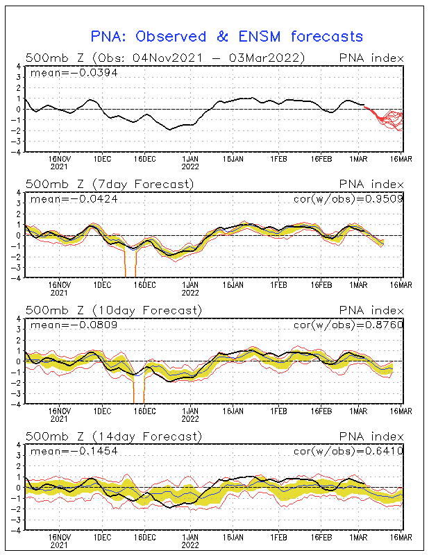
We’ll take a look at the PNA first. The PNA (Pacific North American pattern) tends to influence the locations of ridges and troughs in North America. When the PNA is negative, the east tends to be under the influence of a ridge while the west is under a trough. The opposite is true for a positive PNA. More on the PNA: http://www.nc-climate.ncsu.edu/edu/k12/.PNA

Looking at the graph above, (focus on the first/top one) we can see that April has been under the influence of a positive PNA. Ensembles (lots of models) point to a more negative PNA by the end of the month. (even though the negative PNA may come mid-month, the effects may take a few days to take hold). This may lead to a warmer pattern in the east while the west slides into a cooler and wetter pattern.

This is only one factor in the climate realm. There are others that can trump the effects of the  PNA and vice versa, or they may add to it. The NAO (North Atlantic Oscillation) also lends to the idea of a warming east with the west cooling down. The NAO is negative now, which favors high-latitude blocking and cooler weather in the east, which is what we are seeing. The NAO is slated to go positive next week and this tends to lead to a warmer east. The NAO doesn’t have as large of an influence in the west, where the PNA is more important. Since these two climatic indicators line up, that lends to the idea of a warming east and cooling west, at least in the mid-range.

So, in conclusion, we can expect the cooler than normal weather in the east to continue until the weekend. The trough breaks down later this week and warmer weather will move in this weekend and continue into next week. The west will remain warm until the effects of a negative PNA take hold, if they do. These effects may be delayed though, arriving later in the month. Also, for those in the lower Great Plains, the trough in the west may lead to a greater chance of showers and thunderstorms along with continued warmth. Only time will tell! This is not a day-to-day forecast, it is a general pattern forecast. While any one particular day may not be warm or cool, on average the aforementioned conditions will be the case.

Posted in Uncategorized | Leave a comment

An early start for ants.

A record warm spell across much of the eastern U.S has lead to the early emergence of many ant species here in eastern New Jersey. Temperatures over the past two weeks have been in the 70s and at times close to 80. Though the cool weather has returned, many ant species have come out of hibernation.

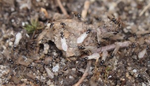
The first to take advantage of the warm weather was Prenolepis imparis. As mentioned in earlier posts, this ant prefers cool weather but will have its nuptial flight on the first 70 degree day in late winter / spring.

I managed to capture a few images of these ants in their flight. Here are a few (click to enlarge):


Even some mound-building Formica were out and about repairing their nest:

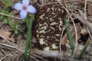
I also stumbled upon an entire colony of Ponera pennsylvanica (left) as well as an entire colony of Tapinoma sessile (right):


Tetramorium sp. E made an appearance as well. Most colonies were busy collecting food or excavating their nest … however, some were engaged in large territorial wars. Early in the spring time, colonies of these ants will battle in order to set up territorial boundaries. The losing colony will usually have a much more restricted foraging area. This year saw an unusually early start to these wars.


Many other species of ants were out taking advantage of the warm weather. Species from Crematogaster, Camponotus, Stenamma, Lasius, Formica, Temnothorax, Myrmica, Aphaenogaster, Pheidole, and Monomorium were all present.

I have pictures of these ants, but to save space I will not include them in this post. Thanks for reading.

Posted in Uncategorized | 2 Comments

East Coast Snowstorm this weekend?

A very interesting and tough to forecast snowstorm looks like it will affect the eastern part of the country this weekend.

The storm will originate in Texas and then move northeast towards the mid-Atlantic region. What it does there is a matter of debate. Odds are that this will not be a major east coast snowstorm, and here are the reasons why:

  1. Lack of phasing (this will keep the storm to the south, and weaker)
  2. Positive NAO/AO (this will allow the storm to move through quickly)
  3. West Coast trough (this will also allow the storm to move quickly)
  4. Positively tilted trough (this will keep the storm weaker)
  5. Time of Day (this may cause snow to melt on contact with the ground if it is now heavy)

A few days ago some of the computer models were showing the northern jet stream merging with the south jet stream. These two features now look like they will miss each other. The northern system will move faster than the southern storm. Without phasing, the southern storm will lack the energy to come north and will likely slide out to sea. This is the current scenario as depicted by model consensus.

This map shows the possible locations of the storm through 72 hours. Each color represents a different time while each point represents a different model. These ‘clusters’ give us a good indication where the storm may go, but exactly where is still an unknown.

Take a look at hour 60, in pink, and you’ll see quite a spread north to south of possible storm positions. With storms like this, a shift in track of only 50 miles can have huge implications … ranging from just cloudy skies to inches of snow.

Why is this? The northern edge of the storm will be very tight. The distance from no snow to lots of it will be within 100 miles. The reason for this is an area of high pressure to the north and west. The high will pump cold, dry air into the northern part of the storm. While this is good for snow, the fact that it is dry is not. The dry air will erode part of the storm, causing the snow to stay further south.

Take a look at this map. You’ll notice the storm on the east coast. But how can you interpret this map? Here’s how: green and blues are precipitation amounts in inches, the red and blue dashed lines are atmospheric thicknesses (literally how thick that layer of the atmosphere is) and the black solid lines are pressure.

If you look at New Jersey, which is a pretty small state, you can see that the southern part of the state has a moderate amount of precipitation while the northern half is dry. The high pressure to the NW is preventing the storm from spreading that far north. Though, this is only ONE model, there are others and they have the storm even farther south, which shows no snow for any of NJ.

Also notice the trough along the west coast. This feature acts as a ‘kicker’ system which will move the storm along at a quick pace. Since the storm is moving so fast, the snow will have less time to fall, reducing amounts. Also, the fact that the NAO (North Atlantic Oscillation) is positive, this will allow for a much more progressive flow as well. A positive NAO allows storms to move quickly through the flow, since it does not favor ‘blocking’ over Greenland. Blocking means that storms are physically blocked from moving quickly or at all by another weather system.

Lastly, since most of the snow will be falling during the day, a lot of it may melt as it hits the ground. The sun angle is increasing with every passing day now, and since this is the last full week of February you will need moderate to heavy snowfall rates to get accumulations.

These factors lead to a less than impressive snow storm, by east coast standards, but is there a chance that it could be worse? Well, there’s a chance, a very small chance. The pattern this year, which has been dominated by La Nina, has led storms to come farther north than modeled. While this is still a possibility, the probability of this happening diminishes every passing day.

Once thing that may allow this storm to move a bit farther north is an area of low pressure near Newfoundland, Canada. This area of low pressure may amplify the weather pattern across the USA and cause our storm to jog a bit to the north. However, since our storm is working with a positively tilted trough, it will be weaker and faster, possibly negating any influence from the Newfoundland low.

With these factors all in consideration, here is my take on the storm. This is my first call:

Again, this is just my first call. If anything changes I will update the map quickly. This is a highly uncertain situation, and lots of factors are on the playing field that can influence the outcome of this storm.

Posted in Uncategorized | Leave a comment

Ants, ice halos, and a sun pillar

The last two weeks saw some wild swings in the weather here in New Jersey. Jumping from warm, spring-like conditions back into winter in the matter of days. The middle of winter is not normally considered a good time to look for ants, or any insects for that matter.

More unusual, is finding ants actively foraging during a snowstorm. As strange as that sounds, that is exactly what I found! Here, a lone Prenolepis imparis worker is inspecting a snow-covered leaf for food.

An unusual sight, no? This ant is commonly referred to as the Winter Ant. That is because this ant is typically active during cooler seasons. In fact, they are dormant through most of the summer!

There is officially only one species of Prenolepis in the United States. There are a few different varieties though. Here in NJ, we have a larger dark version along with a smaller pale version. I caught the two varieties engaged in battle before the snow set in.

The darker variety of P. imparis can be seen on the left, while the paler version is to the right. The pale version here takes on an orange/brown color.

The past two weeks have also been full of nice halo displays. Unlike in Florida, the 22-degree halo was very prevalent this time around.

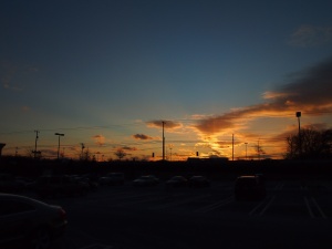
Also, I managed to take a picture of a Sun Pillar as the sun set the other day.


In the image on the right, also noticeable are crepuscular rays. These are caused by sunlight being blocked by clouds in this case. I’m not sure, but a sun pillar may also be visible in the image on the right.

A sun pillar (as in the image on the lower left), is a vertical column of light extending upward from the sun. They are not vertical rays, but instead are the collective glint of millions of ice crystals.

This is the first time I’ve ever witnessed a sun pillar. It was a very cool experience, and it only lasted about 10 minutes.

(More on sun pillars: http://www.atoptics.co.uk/halo/pillar.htm )

Posted in Uncategorized | Leave a comment

Trip to Florida

This will be the first post of this blog. For now, this blog is experimental and is a work in progress as I learn how to get things going on here.

Recently, I drove to Florida with my girlfriend and stayed down there for about two weeks. While there, I found a great variety of ants and other insects. This was a pleasant surprise for me since, here in New Jersey, most wild life is hibernating this time of the year.

In total, I found close to twenty species of ants, many of which were completely new to me. I took this opportunity to practice my macro photography skills. Here is a list of the ants I found while in Florida:

  • Solenopsis invicta
  • Pogonomyrmex badius
  • Pheidole metallescens 
  • Pheidole dentata
  • Pheidole morrisii
  • Pheidole floridana
  • Dorymyrmex sp. (2)
  • Crematogaster sp. (2)
  • Camponotus floridanus
  • Camponotus planatus
  • Odontomachus sp.
  • Paratrechina sp.
  • Cyphomyrmex sp.
  • Prenolepis imparis
  • Ponera sp. 
  • Pseudomyrmex sp.

I will not show a picture of all of these ants as that would take up too much space. I’ll show some of my better shots in no particular order.

These are just four of many shots I took while on vacation. Aside from ants, I also took a few pictures of interesting meteorological phenomena while in Florida.

Most of what I found can be classified as ice halos. A few days of my trip featured a high layer of cirrostratus clouds. These clouds are mainly composed of tiny ice crystals in most latitudes, even as far south as Florida. A unique property of these ice crystals is that they reflect and focus light into interesting features.

I stayed along the Gulf Coast, near Tampa, until sunset to capture the event on camera. Fortunately for me, right as the sun was setting a patch of high cirrus clouds came in and created a spectacular ice halo display. I managed to capture sundogs (faintly visible), the 22-degree halo (faintly visible) , the upper tangent arc, and the sunvex parry arc.

The first three are considered common, and can be seen as often as twice a week in many locations. However, the Sunvex Parry arc is considered rare.

These halos are very photogenic, but how did they come to be? It all has to do with how the ice crystals in the clouds are aligned. According to Atmospheric Optics (http://www.atoptics.co.uk/), they state:

“First recorded in 1820 by Parry during his search for the North West Passage, the arcs are rare. The column crystals with their long axes nearly horizontal which form tangent arc are even further constrained in the Parry orientation ( http://www.atoptics.co.uk/halo/parry1.htm  to see a diagram of Parry orientation). Parry oriented crystals have their long axes and their upper and lower prism side faces nearly horizontal.”

With a portion of the crystals in the cloud aligned in the Parry orientation, I was able to capture these amazing images.

Posted in Uncategorized | Leave a comment